
Fullerton ZIP Coverage
Fullerton’s principal general-delivery ZIP codes are 92831, 92832, 92833, and 92835. Institutional and specialized references include 92834, 92836, 92837, and 92838. The area labels below are practical orientation drawn from local GIS and postal usage. USPS does not publish an official prose neighborhood-boundary table for these ZIP codes, so none of the labels is a legal boundary or proof that an address sits inside the Fullerton city polygon.
| ZIP | Areas Covered | Post Office | Notes |
|---|---|---|---|
| 92831 | Eastern and central Fullerton, Raymond and Lemon areas, education corridor | Fullerton delivery routes | Near Placentia and Anaheim edges; verify city limits |
| 92832 | Downtown, south-central and west-central Fullerton, Civic Center | Main Fullerton postal identity | Compact older core; useful for directory and Sanborn research |
| 92833 | West, southwest, and northwest Fullerton | West Fullerton delivery routes | Approaches Buena Park, La Mirada, and La Habra; verify municipal side |
| 92835 | North and northeast Fullerton, Sunny Hills, Laguna Lake, St. Jude vicinity | North Fullerton delivery routes | Irregular Brea and La Habra edge; includes lower-density hills |
| 92834 | Institutional and unique mailing use associated with Cal State Fullerton | CSUF mailing ZIP | Not a normal neighborhood-wide resident slice |
| 92836-92838 | Specialized and PO-box references associated with Fullerton | Specialized or PO-box use | Verify current USPS status; do not map as residential districts |
The Orange County Assessor parcel-map gateway adds parcel context beside a ZIP search.
Parcel lines help narrow an address, but they do not turn a postal code into a household roster. Use the ZIP as the first geographic cut, then verify the physical address and jurisdiction.
92834 deserves special care. It is associated with Cal State Fullerton mailing and functions as an institutional clue, not a conventional neighborhood slice. The same caution applies to 92836-92838 until USPS confirms how a particular address is delivered.
92832 Fullerton ZIP Core
92832 is the clearest historic-core orientation in the Fullerton ZIP directory. It covers downtown and south-central or west-central areas around the Civic Center, where City Hall, the library, and older street grids make postal and civic clues especially useful. A 92832 address can lead to Fullerton Public Library local-history material, city records, historic newspapers, and the Sanborn and directory sources used in house research.
The ZIP does not replace a parcel or city-limit check. A postal Fullerton label tells the carrier where to route the mail. Fullerton GIS determines whether the physical point falls inside the city boundary, while Orange County offices control county records. For a historic name search, save the exact street number and suffix, then compare the address with the library’s street maps and any old city directory section.
Downtown context also helps with changing names. Harbor Boulevard runs north to south through central Fullerton, while Commonwealth and Chapman are major east-west references. A directory page, a map sheet, and a parcel description can preserve the same place even when a postal or street label shifts.
92831 Fullerton ZIP Corridor
92831 orients the eastern and central side of Fullerton, including areas around Raymond and Lemon and the education corridor. The postal footprint reaches near Placentia and Anaheim edges, so a Fullerton mailing label should not be treated as proof of Fullerton government jurisdiction. The ZIP is a useful first filter for a known address, not a final answer about a parcel or resident.
For current geography, place the address in the City of Fullerton GIS service and turn on the ZIP, Address, Parcel, and City Limit layers. A mapped point can show whether the postal area and city polygon agree. If the question is about a campus or school-era person, CSUF, Fullerton College, and school yearbooks may provide a better time marker than a current postal category.
Keep education-corridor labels as orientation only. They do not define school enrollment, neighborhood membership, or a person’s residence.
92833 Fullerton ZIP Edge
92833 covers west, southwest, and northwest Fullerton in postal terms. Its orientation reaches toward Buena Park, La Mirada, and La Habra boundaries, which makes the city-limit layer more important than the place name printed in an address. A street can feel like one neighborhood while the city record, county office, and delivery route point to different jurisdictions.
Use USPS address verification for the exact deliverable ZIP, then use GIS for the physical side of the line. A permit, parcel, or city public-record request belongs with the government unit that holds that address. A county deed or court case remains an Orange County record even when postal wording changes. The distinction keeps a ZIP directory from promising a boundary it cannot prove.
West-edge research also benefits from historic maps and the Fullerton library’s local files. Street-name changes, annexations, and old house numbers should be bridged with an APN or legal description rather than guessed from a current ZIP label.
92835 Fullerton ZIP Hills
92835 is the north and northeast orientation in the Fullerton ZIP directory. It includes Sunny Hills, Laguna Lake, the St. Jude vicinity, and lower-density hill areas. The edge near Brea and La Habra is irregular, so a 92835 address still needs a city-limit test before a city permit, council map, or municipal record is chosen.
North Fullerton properties can be spread across larger lots or distinct parcel shapes. GIS can show the parcel and address point, while the assessor gateway or counter can supply assessment context. The mapped parcel may show where a structure sits, but it does not identify every person connected to it. Keep property evidence separate from resident evidence.
A historical address in the hills may also be outside the earliest Fullerton townsite Sanborn coverage. A library directory, later aerial, landmark file, or tract record may be a better companion than assuming that one old map covers the whole present city.
92834 Fullerton ZIP Quirk
92834 is the institutional quirk in a Fullerton ZIP directory. It is notably associated with Cal State Fullerton mailing, so it can point to an institution, campus publication, archive, or unique delivery use rather than a normal residential neighborhood. A person found through a 92834 mailing clue may be tied to an organization or campus record, not to a general household address.
92836, 92837, and 92838 also appear as specialized or PO-box references in postal reference data. Exact deliverability and current status need an address-level USPS check. Those references should not be drawn as residential districts, and a ZIP-only search should not be used to infer a list of people.
Postal clue. A unique or institutional ZIP identifies a delivery arrangement. It does not define a neighborhood, prove city limits, or establish where an individual lives.
For campus history, use the Pollak Library and Online Archive of California collection descriptions, then ask the archive about the yearbook, newspaper, or university record that holds the name.
Fullerton ZIP Search Portals
The City of Fullerton MapServer is the local portal that actually exposes a ZIP layer for map display and query. The voter and RecorderWorks tools do not offer a lawful public ZIP resident list. SOS and unclaimed-property searches accept identity, city, or address fields rather than a precise ZIP polygon. The assessor’s external ParcelQuest capabilities were not verified, so an owner-name or ZIP export should not be promised.
| Fullerton GIS MapServer | ZIP, parcels, addresses, city limit, zoning, private streets, and related layers; query a bounded area. |
|---|---|
| USPS lookup | Verify whether a complete street address receives the ZIP entered. |
| Voter tools | Self-status and approved file purposes; no casual ZIP resident search. |
| RecorderWorks | Grantor, grantee, date, document, instrument, or book/page search; no ZIP resident list. |
| Assessor or ParcelQuest | Assessment and parcel information; public ZIP owner search was not verified. |
| SOS and unclaimed property | Name, city, address, or entity clues; not a mapped ZIP population. |
The Fullerton GIS ZIP and parcel layer service documents the local layer set.
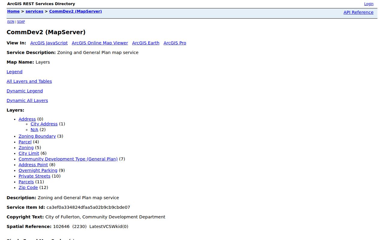
That service can narrow a geographic question without pretending that a parcel map is a resident database. Smaller queries are safer and easier to verify.
To find address records within one ZIP, use this order:
- Enter the complete street address in the USPS address lookup and save the returned ZIP and postal city.
- Open Fullerton GIS, enable the ZIP, Address, Parcel, and City Limit layers, and query the smaller ZIP area.
- Record the address point and assessor parcel number (APN) for each parcel that matters, watching the 1,000-record service ceiling.
- Use the assessor channel for parcel context, then use RecorderWorks by party or instrument when a deed question follows.
- For a person question, switch to the appropriate official record. Voter and recorder systems do not supply a casual public ZIP roster.
Once a ZIP narrows to a street, the Fullerton street directory supplies the address-keyed workflow. A ZIP code directory should hand off at that point rather than repeat a street-by-street record search.
Fullerton ZIP and City Limits
Postal Fullerton and city-limit Fullerton are related but not identical. USPS assigns a delivery name and ZIP. The Fullerton GIS City Limit layer determines municipal jurisdiction. Orange County offices cover countywide deeds, assessment, courts, voter systems, and local vital records. Therefore a Fullerton postal address can sit outside the city service boundary, while an institutional or edge delivery arrangement can obscure ordinary ZIP geography.
Boundary mismatch. Use USPS to verify delivery, Fullerton GIS to verify the physical city line, and the named record custodian to verify which office holds the record. No single ZIP field answers all three questions.
For an old address, compare the current city polygon with an APN, legal description, historic street map, Sanborn sheet, or neighboring landmark. Fullerton Heritage warns about street-name and house-number changes. A legal parcel can preserve continuity after a postal label changes, while a modern ZIP can hide an earlier townsite name.
District maps for schools, zoning, council, utilities, or permit parking answer their own questions. They do not identify residents and should not be read as ZIP boundaries.
Fullerton ZIP Terms
Four postal terms prevent the most common mistakes in a Fullerton ZIP directory. They describe delivery mechanics, not the legal identity of a person or parcel.
- ZIP vs ZIP+4
- A ZIP code is the five-digit delivery area; ZIP+4 adds four digits for a more precise route or segment within that delivery system.
- PO-box ZIP
- A ZIP used mainly for post-office boxes or a specialized postal unit, not a map of nearby homes.
- Unique ZIP
- A ZIP assigned to one institution or a narrow organization-based delivery use, such as a campus mailing clue.
- Carrier route
- A delivery path within a ZIP, useful for postal operations but not a municipal neighborhood or public resident list.
Use the five-digit code for broad orientation, ZIP+4 only when the address is verified, and a parcel or city-limit layer for government jurisdiction. A carrier route or PO-box reference should not be plotted as if it were a residential district.
Fullerton ZIP Directory Caveats
ZCTAs are Census statistical approximations, not USPS delivery polygons. A ZIP directory that borrows population or demographic figures from an ACS ZCTA is describing a statistical area, not proving where the carrier draws a route. The same caution applies to neighborhood names such as Downtown, Golden Hills, Sunny Hills, Amerige Heights, West Fullerton, Raymond Hills, Richman, or the Cal State Fullerton and Fullerton College areas. They orient a search but do not replace a jurisdiction or ZIP check.
Fullerton’s GIS service reports a 1,000-record maximum and publishes a downloadable city address-point dataset updated through August 29, 2019. Query smaller geographies, save the date of the layer, and verify newer construction by address. A map service is precise about the layer it serves, but it can be recent, filtered, or incomplete for a particular record question.
When no portal offers the needed record, a targeted California Public Records Act request can ask for an existing city record series by address and date range. Government Code division 10 §§7920.000-7931.000 and §7922.535 do not require an agency to create a ZIP-indexed resident list. The legal answer remains tied to the custodian, the record type, and the lawful purpose of access.
A useful ZIP directory ends with that restraint. Verify the address, separate postal and civic geography, use the portal that actually accepts the field, and preserve the source note for every conclusion.